Explore Nearmap's Self-Guided Tours

Nearmap and Carahsoft have partnered together to provide a series of self-guided tours of Nearmap's products and features. Similar to a live demo, the self-guided tours explores how Nearmap's products and features applies to a specific technology vertical such as Geospatial.


Learn about Nearmap's benefits, watch a short pre-recorded demo video, and download related resources. If interested in furthering the conversation, you can also schedule a live demo with a Nearmap expert from Carahsoft. Start a Self-Guided Tour now by selecting one below: 


Nearmap Geospatial Self-Guided Tour

Nearmap Geospatial Self-Guided Tour

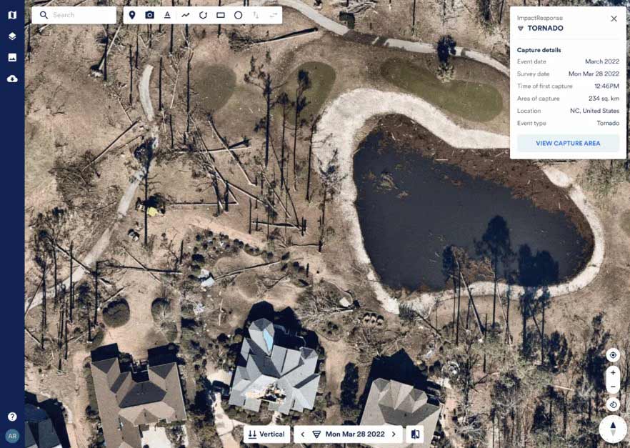
Nearmap’s cloud-based subscription model provides businesses instant access to high-resolution aerial imagery, city-scale 3D datasets and integrated geospatial tools, helping thousands of users everyday conduct virtual site visits for deep, data-driven insights. Multiple times each year, up-to-date imagery of covered areas is published in the cloud, powering projects with richly detailed location information across the globe. Nearmap offers a full suite of web browser measurement and analysis tools, it can also be integrated with leading GIS and CAD platforms. Receive unprecedented access to detailed visualizations, view multiple image captures simultaneously, conduct side-by-side image analysis and perform advanced change detection with one of the ten largest aerial survey companies in the world.


Want to learn more about Nearmap?
Start a self-guided demo now to learn how to make informed decisions, streamline operations and save on costs.
1 of 5

Vertical Imagery

Nearmap Vertical provides high-resolution, top-down aerial imagery with a ground sampling distance of 4.4–7 cm per pixel, offering sharper detail than satellite images and broader coverage than drones. Captured multiple times annually, this georeferenced imagery ensures up-to-date visuals and includes a comprehensive historical archive dating back to 2014. Accessible via web applications, GIS platforms, and APIs, Nearmap Vertical facilitates seamless integration into existing workflows. NEARMAP

Benefits:

  • Enhanced Urban Planning: High-resolution, frequently updated imagery enables precise infrastructure development and planning, leading to more informed decisions and effective project outcomes. NEARMAP
  • Improved Asset Management: Accurate visualization of assets, such as utility corridors, allows for better maintenance scheduling and risk assessment, enhancing public safety and resource allocation. NEARMAP
  • Efficient Emergency Response: Timely access to current aerial imagery aids in rapid damage assessment and coordination during disaster response, facilitating quicker recovery efforts and informed mobilization of resources. NEARMAP
2 of 5

Oblique Imagery

Nearmap Oblique is an imagery subscription product that provides access to Nearmap's repeat capture (5.5-7.5 cm) vertical, (7.1cm) panorama and (7.1cm) oblique content.

Benefits:

  • Customers can choose to consume Nearmap vertical & panorama content through MapBrowser, API or partner products such as ArcGIS online.
  • Nearmap oblique data can be integrated via Nearmap Obliques for ArcGIS.
  • Nearmap Obliques offer precision measurement capability.
3 of 5

Nearmap 3D

Nearmap 3D is a 15cm 3D model subscription that provides yearly updates on Nearmap elevation data for the subscribed region.

Benefits:

  • Offers wide-scale, photo-realistic 3D models and elevation datasets across Australia and North America.
  • Access to these yearly updated 15cm 3D models across our oblique coverage footprint in textured mesh, DSM, DTM, Point Cloud or TrueOrtho format.
  • Access to the 3D Viewer in MapBrowser allows customers to view and interact with Nearmap 3D Textured Mesh & TrueOrtho within the MapBrowser application.
4 of 5

Nearmap Impact response

Nearmap ImpactResponse provides high-resolution, post-catastrophe aerial imagery and AI-driven damage assessments, enabling public sector agencies to swiftly evaluate disaster impacts and allocate resources effectively.

Nearmap Impact response Nearmap Impact response

Benefits:

  • Quick response to catastrophe: Access to detailed post-disaster imagery, often available within 24 hours, allows for rapid evaluation of affected areas, facilitating timely response efforts.
  • Informed Resource Allocation: AI-powered damage classifications help prioritize areas with severe damage, ensuring that emergency services and aid are directed where they are most needed.
  • Enhanced Communication: Providing accurate, up-to-date information to the public and stakeholders improves transparency and coordination during disaster response and recovery operations.
5 of 5

Nearmap AI

Nearmap AI leverages high-resolution aerial imagery and advanced analytics to deliver precise insights into over 130 property features, streamlining workflows and reducing the need for on-site inspections. Designed for public sector needs, it enhances decision-making in urban planning, infrastructure management, and environmental monitoring while integrating seamlessly with existing systems via exportable data and APIs.

Benefits:

  • Reduces the necessity for time-consuming on-site inspections, allowing public sector agencies to allocate resources more effectively.
  • Provides up-to-date insights on various property aspects, such as surfaces, vegetation, and roof conditions, enabling agencies to make informed decisions in areas like urban planning, environmental monitoring, and infrastructure management.
  • With the capability to export AI-generated vector layers and integrate them via APIs, Nearmap AI ensures that valuable data can be easily incorporated into existing public sector platforms, enhancing workflow efficiency and data accessibility.

Nearmap’s Benefits Snapshot:


  • Quality at scale that’s always current
  • Built for businesses and easy to use
  • Largest data collection with searchable imagery archive