


LightBox for Government: Unifying and standardizing nationwide data from over 10,000 sources
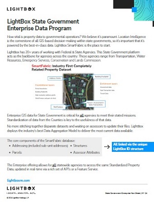
How vital is property data to governmental operations? We believe it’s paramount. Location Intelligence is the cornerstone of all GIS-based decision-making within government today, so it’s important that it’s powered by the best-in-class data. Our goal is to make location data accessible to ensure you can make every decision with confidence. LightBox has 20+ years of working with Federal & State Agencies to help them deploy Enterprise GIS datasets that are critical for all agencies to meet their stated missions.
Our foundational data sets include:
- Parcels
- True Owner
- Assessments
- Addresses
- Geocoding
- Buildings
- Addresses
- Zoning
- Transaction History
- Building Footprints
- LightBox ID
- Full list here and here
LightBox adds value to this data in a number of ways:
- LightBox unique and persistent ID structure
- Enables data connectivity across first party and LightBox datasets
- Normalization – One data model built for easy integration
- Modeled insights to fill in sourcing gaps
- Standardized land use codes
- Residential/multi-family unit counts (RUC)
- Address confidence score (ACS)
- Acres
- Aggregated acres
- Building size
- Number of stories
- Digitizing Paper Maps
- Dedicated data acquisition teams for complete coverage and currency
- Dedicated support and customer success