AVAILABLE 24x7
888.662.2724
AVAILABLE 24x7
(888) 66CARAH
Fast & Accurate
Request A Quote
Quick Response
Chat With Us

Veritas Technologies Datasheet
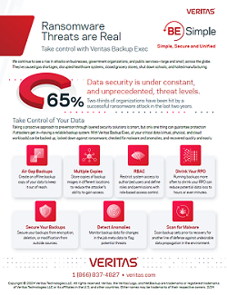
Ransomware Threats are Real
Thank you for your interest in this resource!
Ransomware Threats have real impact on businesses, government organizations, and public services, no matter the size of the threat. Take control of your data with Veritas Backup Exec, made to protect critical data at all stages of its life, no matter where it is.


